This site uses cookies.
Some of them are essentials while other help us improve your experience. Read Our Privacy Policy


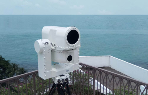
Jane’s IDR: CONTROP Launches TORNADO-ER Dual Sensor Panoramic Infrared Scanning System
Controp Precision Technologies unveiled its Tornado-ER all-weather panoramic scanning system at the EURONAVAL 2018 exhibition held 23–26 October in Paris.
The Tornado-ER, part of a range of day/night-capable systems developed for coastal surveillance, force protection (FP), and maritime traffic monitoring, enables continuous panoramic infrared image and video capture at a frequency of 3 Hz. The system provides real-time data analysis and automatic target detection capabilities at ranges from 400 m to 12 km, the company said.
The dual sensor Tornado-ER comprises a gyro-stabilised sensor head housing two thermal imaging channels. The first thermal imager features a 100 mm focal length lens with a 5.52° field of view (FoV), and the second thermal imaging channel uses a 400 mm lens with a narrower 1.38° FoV. Both thermal imagers use cooled medium wave infrared (MWIR) XBN detectors sensitive from 3 µm to 5 µm, each with a 640×512 format focal plane array (FPA).
The use of two thermal imagers with different focal length lenses enables simultaneous short- and long-range detection of targets including small floating objects, combat swimmers, and vessels of all sizes. Controp said the system can detect a 3 m boat at a range exceeding 5 n miles.
The system includes specially developed software that enables automatic area scanning, threat alerts, automatic target tracking, image processing, and video enhancement. The software algorithms enable the system to detect threats in cluttered sea environments.
Tornado-ER is passive in operation and not directly affected by radio frequency jamming. The system is suitable for standalone operation or integration with wider command-and-control (C2) systems and it accepts connections from radar, GPS, and geographical information systems (GIS). Tornado-ER includes a gigabit Ethernet (GIGE) interface for high-speed network connections and for high-resolution digital video output. The system provides remote control functionality using RF protocol and wireless local area network (WLAN).
Reading: Jane’s IDR: CONTROP Launches TORNADO-ER Dual Sensor Panoramic Infrared Scanning System